| Download | Purchase | FAQ | Home |
Step #1 - Operation Step #2 - Images Step #3 - Web Page Step #4 - FTP Step #5 - Finish
Quick Start Guide Detailed Setup Thumbnail Properties WebPage Appearance FTP Settings Program Automation E-mail Settings HTTP Settings Misc Options GPS Setup HTML Properties Miscellaneous HTML
EXIF Editor Batch Processing Rotating Images
Preview Web Pages View Web Pages Sample Web Page Font Properties
RoboPhoto FAQ What's New in v3.0 Screen Shots Advanced Features HTML Template Files Sign Up With Tripod PAD File (htm) PAD File (xml) Legal Info End-User License
System Requirements Demo Limitations Download The Demo Purchase Unlocking The Demo |
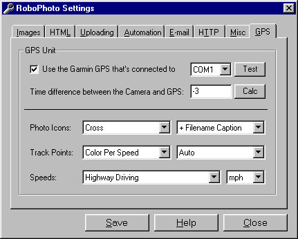
You can add powerful mapping features to your photo galleries by using a supported GPS unit and by selecting the appropriate options from this screen. If you don't want to add mapping to your photo galleries, simply uncheck the 'Use the Garmin GPS...' box and forget about it - here's a sample that does not use georeferenced images. RoboPhoto determines the latitude and longitude of each image by equating the times in the GPS tracklog to the times of the images. Knowing the coordinates, the program can then create links for each picture that point to several popular on-line mapping engines. Using a GPS also allows for the creation of an area map that shows all of the pictures on a single street map along with the actual tracklog. If you don't have a GPS unit, you can still georeference images by manually entering the latitude/longitude coordinates on the EXIF editor screen. There are several things you should consider and/or account for when creating web pages that include georeferenced images. Listed below is a to-do list that illustrates these considerations: 1) Confirm that your GPS unit is supported. See the system requirements page for more info. 2) Confirm that your camera writes EXIF format images (all modern cameras do) OR that your camera writes disk files (like Sony's line of floppy disk cameras) with times that match when the pictures were taken. Note: to read times from the disk file instead of the EXIF headers, you must specify the UseDiskFileDate Misc Option. 3) Turn the GPS on and obtain a position fix. 4) Confirm that the time difference between the camera and the GPS is zero or within your allowable limits. Click here for more info. 5) Turn the GPS tracklog recording OFF. 6) Set the GPS to record tracklog points every X seconds (instead of 'Auto' or 'Distance'). If your GPS model doesn't allow this, set to 'Auto' and skip the next step. 7) Determine the most appropriate value of X by considering the estimated time and the number of trackpoints that your GPS can record. The goal is to record as many trackpoints as possible without filling up the GPS's memory during the time you'll be taking pictures. A good rule of thumb for the tracklog recording increment is this: For every 1000 trackpoints that your GPS can store, each 1 second increment gives you 15 minutes of total recording time. Huh? For example, if your GPS unit can store 1000 trackpoints and if you're recording these every second, you have 15 minutes to take the pictures. If your GPS unit can store 2000 trackpoints and if you're recording them every 16 seconds, it'll be 8 hours until the GPS's memory fill up. A real world example: You own a Garmin GPS 12 (1000 trackpoints) and you anticipate that your journey is going to take 2 hours. What is the optimal tracklog recording increment? If you set it at 1 second, you'll get 15 minutes. That's not long enough so you need to increase the increment. 2 seconds gives 30 minutes. 3 seconds gives 45 minutes. 4 seconds gives an hour. Etc. So, for 2 hours, your increment should be 8 seconds. If you were using a Garmin GPS III Pilot (2000 trackpoint), the optimal increment would be 4 seconds. Got it? 8) Turn the GPS tracklog recording ON and mount it wherever is appropriate (on your dashboard, the top of your backpack, on your handlebars, etc.). 9) Forget about the GPS unit until you're done taking pictures. You can still use your GPS as always - creating GOTOs, following routes, changing batteries, etc. Just make sure that the tracklog recording remains on. 10) Embark on your picture taking journey. If you later find that you need more time, there's no problem with increasing the tracklog recording increment. There's also no problem with turning the GPS off when you're stationary. Just keep in mind that each picture must be taken within the time frame that the GPS is recording a tracklog. 11) When done, turn the GPS tracklog recording OFF. 12) Back at the computer, turn the GPS on and connect it to the COM port. Make sure that the interface mode is set to Garmin's proprietary protocol (not NMEA). Again, at this point, make sure the tracklog recording is OFF so that you don't record bogus tracklog points. 13) Start RoboPhoto, making sure that the 'Use the Garmin GPS...' option is checked. 14) Ensure that you're uploading the web page to a publically accessible web server. This is required in order to create the area map. 15) Create the web page as normal. The result should look something like this. To test the GPS functionality, you don't have to go on a long trip - just walk around in your front yard. You can automatically write the info obtained from the GPS tracklog to each image's GPS EXIF header by specifying the GpsWriteToExif Misc Option. The GpsReadFromExif Misc Option allows you to read latitude and longitude information from the EXIF headers instead of the tracklog. You'll need to specify both of these if you'll be adding new images to existing photo galleries or if your camera is capable of directly recording the GPS coordinates, like some of the high end Nikon models do. Back to the top Use the Garmin GPS Check this box if there's a Garmin GPS connected to the selected COM port. If unchecked, the program will not attempt to download the tracklog when creating a web page. Back to the top GPS COM Port Select the COM port where the GPS is connected. If you select Auto, the program will search for it until it's found. Using Auto will slow things down, so specify it only as a last resort. A better alternative is to just guess at the COM port until the test passes. Back to the top Test GPS Communication Click this button to test the GPS communication. This downloads the GPS's tracklog and writes it as tracklog.csv in the main RoboPhoto directory. Make sure that:
The test also writes 2 additional files named trackloglat.csv and trackloglon.csv. These are standard comma delimited files that you can import into Excel to create graphs of the latitude and longitude data like this and this. Each record contains 4 fields with values based on:
If you don't specify the TrackPointErrorDeviations and TrackPointErrorPeriods Misc Options, the program will use 3 standard deviations above and below a 20 period moving average. Back to the top Time Offset RoboPhoto equates the times in the GPS tracklog to the times associated with the pictures to determine each picture's coordinates. So, to be accurate, either the GPS time must match the camera time OR an offset be specified here to account for the time difference between the two. The offset is expressed in seconds. If the camera's time is before the GPS's time, the number should be negative. Otherwise, it should be positive. For example, if the GPS's time is 11:23:44 and the camera's time is 11:22:43, the offset is -61. Instead of specifying this number each time, you should just simply set the camera's time to match the GPS's time then specify zero for the offset. To set the camera's time, do the following: 1) Turn on the GPS and obtain a position fix. 2) Go to the GPS screen where the time is displayed. Assume, for this example, that the time is 10:22:01. 3) Set the camera's time to 10:23:00, then wait for that time to display on the GPS. When it does, save the camera time. Be quick. The two times should then match or at least be close enough so that it doesn't matter. Since the camera, unlike the GPS, does not keep exact time, you'll need to periodically (maybe once a month) repeat this process to ensure that the times stay in sync. You can also use the offset field to account for other factors that relate to time. For example, if you're using one of Sony's floppy based cameras (and if you've specified the UseDiskFileDate Misc Option), it'll take about 4 seconds to write each image to disk, i.e. if you press the shutter button at 10:11:22, the time would be 10:11:26. You can account for this by subtracting 4 seconds from the offset. The importance of the offset's accuracy depends on the conditions under which you're taking the pictures. Assume that there's a 15 second error in the offset. If you're traveling at 60 miles per hour, the positional error would be 1/4 mile. On the other hand, if you're stopped for at least 15 seconds when each picture is taken, there would be no error. The bottom line is that the error associated with the offset needs to be less than the stationary time when each picture is taken, i.e. if there's a 60 second error in the offset, it won't matter as long as you're stationary for at least 60 seconds when each picture is taken. You can calculate the offset by: 1) Take a picture of your GPS receiver showing the time. 2) Click the 'Calc' button. 3) When prompted, load the image into your normal graphics program. 4) Note the GPS time and enter it in HH:MM:SS format when prompted. 5) Delete the image so that it's not included with the web page. Back to the top Area Map Photo Icon RoboPhoto places an icon on the area map where each picture is taken. Select the icon you want to use from the drop down list. Back to the top Area Map Photo Icon Text You can place text next to each photo icon by selecting it from the drop down list. Normally, so that others can equate the icon with an image in the thumbnail table, you should select '+ Filename Caption'. If you find that the area map is becoming cluttered, you may want to select 'With No Caption' from the list. Back to the top Area Map Track Point Color You can specify the color of the trackpoints from the drop down list. These can be constant, per the speed, or per the direction of travel. If you color trackpoints per the speed, you can select preconfigured speed ranges described below or you can define custom ones by specifying the AreaMapMinSpeedBrown thru AreaMapMinSpeedRed Misc Options. Coloring trackpoints per the direction of travel may be useful if you're backtracking as it would allow you to distinguish the tracks going to or from a given point. A flight instructor could, for example, use it to test a student's ability to fly a straight line, i.e. flying true north and noting how often the direction changes from east/west of north - the goal would be for this to change as often as possible as the plane maintains the northerly track. Back to the top Area Map Track Point Size Select the size of the trackpoints from the drop down list. If you select 'Auto', the program will select the size based on the map coverage, using smaller trackpoints for larger maps. Select 'Small Crosshair' if positional accuracy is more important than visibility. To omit the trackpoints so that only the photo icons appear on the area map, select 'No Track Points'. Back to the top Track Point Speed Ranges If you're coloring the trackpoints based on the speed, select an appropriate preconfigured speed range. If you're hiking, 'Walking or Jogging' would be a good choice. The preconfigured speeds (in mph) are listed below:
If you specify the AreaMapMinSpeedBrown thru AreaMapMinSpeedRed Misc Options, they will be used instead of what's specified here. These options allow you to specify custom speed ranges instead of using the preconfigured ones above. Back to the top Track Point Speed Units Select the units (mph, km/hr or knots) from the drop down list. The speeds listed above will be converted to the units that you select. Back to the top Save Click this button to save the current information to rp.ini, which is located in the main RoboPhoto directory. Back to the top Help Click this button to load the help file. You can also press the F1 key anywhere in the program for context sensitive help. Back to the top Close Click this button to close the form. Back to the top |